Facts and data on pictograms

Synonyms / Other Terms Used
View, Viewing Area, Outlook, Lookout, Scenic Viewpoint, Panoramic View, Panorama, Camera Point
Category
Travel, Tourism, Recreation
Message / Function
To indicate the location of public viewing point
| Source | Description | |
|---|---|---|
 * * |
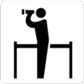
ÖNORM A 3011 | Side view of two human figures standing on circular segment, one looking through binoculars, one pointing in the same direction |
 |
EJP | Side view of human figure looking through telescope on stand |
 + + |
ISO 7001 | Side view of human figure looking through binoculars or telescope on stand |
 |
Eco-Mo Foundation |
Side view of human figure looking through binoculars or telescope, railing |
 |
Bolivia | Side view of human figure looking through binoculars, railing |
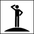 * * |
ON Testdesign | Side view of human figure standing on circular segment, one arm near head |
 * * |
BS 8501:2002 | Side view of two human figures, one looking through binoculars, one pointing in the same direction |
 |
PC | Side view of two human figures, one looking through binoculars, one pointing in the same direction |
 |
Slovenia 2015 | View of two human figure standing on peak, one pointing somewhere |
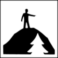 |
SSRS | View of human figure standing on peak and pointing somewhere, tree in foreground |
 |
SADC | View of human figure standing on peak, pointing somewhere, tree below |
 |
Ecuador | Single lens reflex camera with pentaprism viewfinder, arc above |
 |
Dreyfuss | Single lens reflex camera with pentaprism viewfinder |
 |
NPS | Camera with viewfinder |
 |
Galicia | Vintage bellows camera with wire release |
 + + |
RTA Algarve | Parallel projection of binoculars |
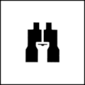 |
Nova Scotia | Binoculars |
 |
Kapitzki | Filled circle, four arrows pointing in all directions |
 |
France IISR | Four rays covering angle of 80°, pointing away from point |
 |
U.S. National Park Service |
Five rays covering angle of 130°, pointing away from point |
 + + |
UKDT | Five triangular rays covering angle of 180° |
 |
SN 640 827 | Five triangular rays covering angle of 180°, pointing away from point |
 |
BTA 1989 | Seven rays covering angle of 180° |
Note: Some of the examples shown above were mirrored horizontally to contrast differences.
Discussion
The range of graphical symbols shown in the table above gives a good hint of the diversity of variants and image contents used to signify the location of public viewing point or panoramic view. As the range of other terms used for this referent discloses, it should be no surprise that no single visual stereotype can be identified.
In a Comprehension Test conducted in Austria (Brugger, 1990) with pictograms for Viewpoint almost identical to the examples above marked with a *, pictogram No 117 from ÖNORM A 3011 reached the best scores, and a variant similar to BSI symbol No 8042 was very close. Both variants had a strong focus on viewing, but some responses to the variant similar to BSI symbol No 8042 indicated a relationship to stands or a visitors' gallery, which maybe could have been eliminated by offering more context information. The variant labeled as ON Testdesign induced confusions related to the military or police and even trampolining.
In the Japanese study to propose domestically unified graphical symbols based on scientific methods, the pictogram variant labeled as Eco-Mo Foundation proved to be well comprehensable with a comprehension score of 79.6 (Eco-Mo Foundation, 2001).
Fiori (2008) examined Viewpoint map symbols similar to the ones at the bottom of the table above, and correct responses were very sparse with values below 10 %. Often no answers were given and wrong responses outnumbered everything else. Frequent answers were for example Light, High Beam, Spotlight, Cinema, and Speaker.
As Neves (2012) compared several variants, marked with a + in the table above, using the Comprehensibility Estimation method, the ISO 7001 Public Information Symbol PI TC 001 for Viewpoint and Panorama was judged as well comprehensable with a mean score of 88.5, closely followed by the pictogram labeled as RTA Algarve, while the map symbol of the UK Department of Transport was judged as rather incomprehensable, reaching a score of 7.7 only.
Recommendation
As the location or context in which a symbol for the concept Viewpoint / Lookout / Panoramic View is used has significant influence on comprehension of this symbol, we suggest to conduct further studies including sufficient context information. Only on such a basis a clear decision concerning a specific recommendation for Viewpoint can be reached.
Tests of pictograms of referent Viewpoint
Brugger, Ch. (1990): Abschlußbericht über den Verständnistest. Report to the Austrian Standards Institute (ON) dated 10/90, Vienna.
Eco-Mo Foundation (2001): Test data of public information symbols in Japan - Procedure for the testing of public information symbols by the Study Committee. ISO: ISO/TC 145/SC 1 N 329.
Fiori, S. R. (2008): Mapas para o turismo e a interatividade - proposta teórica e prática. Tese de Doutorado - Depto. de Geografia, FFLCH-USP.
Neves, J. (2012): Sistema de signos para informação turística: Metodologia para o desenvolvimento de sistemas sinaléticos. Tese de Doutorado - Universidade de Lisboa, Faculdade de Arquitetura.
Updated 2023-11-29 by Ch.Brugger